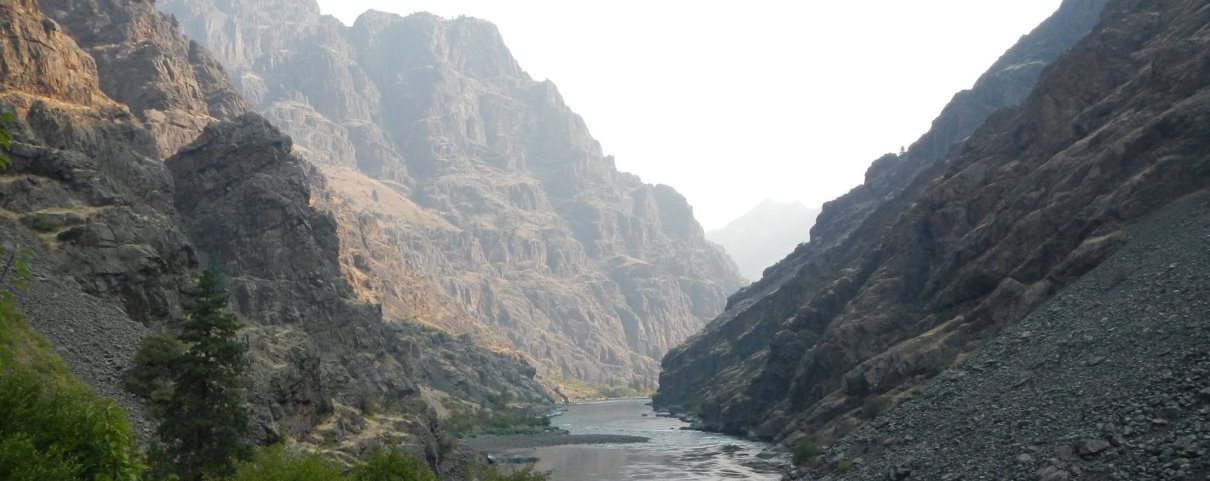
Looking Downstream from Hell's Canyon Launch Site: Photo Copyright Todd Hoffman 2018
Snake River: Hell's Canyon Creek to Pittsburg Landing
Snake River: Hell's Canyon Creek to Pittsburg Landing
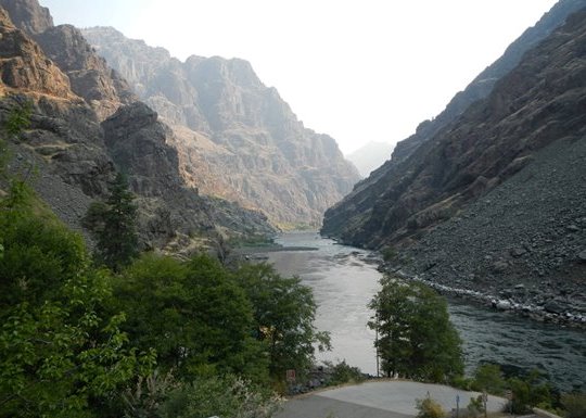
Hell's Canyon Launch Site: Photo Copyright Todd Hoffman 2018
The Snake River and Hell's Canyon:
The Hell’s Canyon reach of the Snake River was added to the National Wild and Scenic Rivers System in 1974
as a political compromise tied to the construction of Hells Canyon Dam. In exchange for flooding irreplaceable
whitewater and river habitat upstream, 32.5 miles of river below the dam were granted “protection” under the Wild and Scenic Rivers Act.
Nearly fifty years later, that promise rings hollow. By any reasonable standard, it is difficult to justify labeling
this reach as “wild.” The river is not free-flowing. Jet boats operate at high volumes for much of the year with
minimal restriction. Human development is evident throughout the canyon, particularly in the lower reaches, eroding
both solitude and ecological integrity. Hydropower operations have profoundly altered aquatic habitat, and historic
domestic livestock grazing—through the spread of disease—nearly wiped out the canyon’s iconic bighorn sheep.
And yet, even in its degraded state, Hell’s Canyon remains one of the last places on the 1,078-mile Snake River where
the public can still glimpse what a wild, free-running river system once looked like. That alone makes its continued
decline unacceptable. If this reach cannot be meaningfully protected, it raises serious questions about the credibility
and purpose of the Wild and Scenic Rivers designation itself.
There have been hard-won successes. The elimination of domestic sheep grazing allotments in 1993 removed one of the
greatest threats to bighorn sheep, giving the species a genuine chance at recovery. After years of conflict, the first
real limits on jet boat traffic were enacted in 1997. Today, 18 days during permit season are reserved for non-motorized
use above Kirkwood Ranch—an important acknowledgment that wild rivers should sometimes be experienced without engines.
But these protections are narrow, temporary, and overwhelmed by motorized use for the rest of the year.
The greatest failure, however, lies in the ongoing collapse of the Snake River’s native salmonids. Elevated
water temperatures caused by upstream impoundments now push these fish to the edge of survival. Dams on the lower
Snake and Columbia Rivers continue to block migration routes essential to their life cycle. Without decisive
action, extinction is not a distant possibility—it is the likely outcome. For many of us, it will happen within our lifetime.
Hell’s Canyon was supposed to represent a lasting commitment to protect what could not be replaced. Instead,
it has become a reminder of how easily “protection” can be compromised when convenience and commercial use
are allowed to dominate. If we are serious about conserving wild rivers, Hell’s Canyon should not be the
exception—it should be the line we refuse to cross.
Run Description:
The run from Hell's Canyon Dam to Pittsburg Landing is 33 miles in length, and can
be easily be done as an overnight trip, especially with high flows.
Unfortunately, the shuttle is 206 miles (one-way), and the put in and take outs are
in extremely remote locations, a full day's drive from anywhere. This makes for a
lot of driving and shuttling for a relatively short float trip.
Given the long logistics, many people either stretch the trip out to three days,
or extend it by floating all the way to Heller Bar near Asotin Washington.
Between Pittsburg and Asotin, the gradient backs off to almost nothing, and
punishing afternoon winds are frequent. Many people chose to bring motors.
Jet boat traffic below Pittsburg is completely unrestricted (and prolific),
and the scenery includes more human development and cow pastures. Significant
mileage and cost are also added to the shuttle by floating to Heller.
Another logistical challenge on Hell's Canyon is camping. Unfortunately, the
dam has effectively cut off the river's natural flow of beach building sediments.
With this, the constantly fluctuating discharge for power generation, and the highly
erosive actions of jet boat wakes have consumed almost all the last remaining natural beaches.
With no natural beaches or bars, nearly every campsite involves carrying gear up steep,
rocky banks to find a mediocre spot. Wild fluctions in daily flows usually mean waking up
to boats sitting high and dry. Tie up your boat very carefully to accomodate high and low water marks.

Water levels fluctuate wildly overnight: Copyright Todd Hoffman 2018
Note that all camps are first come, first served, and the best spots fill in quickly.
Plan ahead and have a plan B. During summer, also give serious consideration to where you will find shade. It's not
uncommon for July and August temps to break 110 degrees. I've had to stop mid-day and hunker down
under low willow bushes and mahogony to get respite from the heat. A shade shelter of some sort is
highly recommended. Given the hot, dry conditions, campfires are prohibited in the canyon most of the year.
Be vigilant for posion ivy and rattlesnakes when in camp and scouting. Both thrive in the riparian zone.
As with any river in Idaho, never attempt to share a campsite with another group. It is considered a serious breach
of river etiquette.
From the launch site down to Sheep Creek, the river moves at a fast pace through a vertically walled gorge
with several nice rapids. The two stand out drops are Wild Sheep and Granite (class III/IV).
At low to medium flows, both are fairly straight forward, but definitely require a plan and some moves.
Scout river left. Most of the other drops are read and run (for skilled boaters), but there are a
few must make moves thrown in, so don't be too nonchalant. The section jumps a notch in difficulty above 25,000 CFS.
There is an historic ranch at Sheep Creek, which is now owned by the US Forest Service, and
operated under lease to a private outfitter (Hells' Canyon Adventures). There is a full-time
caretaker on site, and large commercial groups frequently camp and lunch there. You can stop
and tour the site and get some wonderful shade if it is not occupied by commericial groups.
It is possible to reserve rustic accomodations in the old ranch house, though it requires
booking far in advance. Reservations are made through the outfitter, not through Recreation.gov.
See link under planning tools. Note that there is a first come, first served campsite on a
small bench just below the ranch at the mouth of Sheep Creek, but camping on the actual
ranch grounds is not allowed without booking through the outfitter.
Scenery along the reaches of the canyon below Sheep Creek: Photo Copyright Todd Hoffman 2018
Below Sheep Creek, the canyon starts to open up into wide grassy valleys, and the gradient starts
to slowly dimish. Fortunately, the current still moves at a fairly good pace, and there are quite a few
long class II+ / -III rapids to keep things interesting. The Wild section of Hell's Canyon
ends at the historic Kirkwood Ranch, which is also now owned by the US Forest Service.
Kirkwood Ranch is staffed by a full-time care taker, and there is a small museum on site and also
restrooms with flush toilets. Five designated, developed campsites are strung out along the
high bench below the ranch. Unfortunatley, none of them have good river access, and poison ivy is prolific along
the banks. The entire camp section is sort of like one big a cow pasture. Below Kirkwood, gradient continues
to diminish, and the current slows up a notch or two. Expect to slog some flatwater between here and Pittsburg.
Campsites below Kirkwood are sparse, and tend to be full of jet boaters during motorized periods.

Hell's Canyon Creek Launch: both the put in and take out have concrete ramps: Copyright 2018
Logistics:
The shuttle from the put in at Hell's Canyon Dam, to the take out at Pittsburg
Landing is 206 miles one-way. From within Idaho, best access to Hell's Canyon
Dam is from Cambridge, Idaho. From Cambridge, take Highway 77 West for
62 miles. Be sure to top off your fuel tank in Cambridge.
To get to the take out, return to Cambridge and take highway 95 North for 108 miles towards
the town of Whitebird. Just before Whitebird, watch for signs on the left for Old Highway 95 / Hammer
Creek Recreation Area. Turn off here and follow the Salmon river for a short
distance to Dumec Road / FR 493. Cross the bridge and go West on 493 for
18 miles to Pittsburgh Landing. Note that there is significant elevation gain and loss
between Pittsburg Landing and Whitebird, so keep an eye on the air pressure in your
inflatable boats.
Given the length of the shuttle, most people choose to hire a shuttle service, with
prices starting in the range of $250 per vehicle (as of 2018). Some services will charge a
significant premium for non-cash payments so bring cash, including extra for a fuel
deposit and tip. Hell's Canyon Shuttle Service operates out of Scotty's Service Station
near Oxbow Dam on the Oregon side. Scotty's sells fuel, ice and propane, but closes at 8:00 PM Pacific time.
Whichever service you use, be sure to reserve in advance. See link under planning
tools for shuttle provider contact details.
If using a boat trailer, be extra careful on the boat ramp at Pittsburg Landing.
It is covered in extremely slippery slime below the water line. Do not back the rear wheels of
your vehicle into the water onto the slime (especially with 2 wheel drive) as you will not be able
to get traction to get out. Also be extremely careful if wading into the water here. The ramp slime is
literall slippery as ice. I've seen bears at Pittsburh landing on more than one
occasion, practice bear safety measures if camping there.
Please observe Idaho etiquete standards at the boat ramps. Rig your boat before backing
down the ramp, get in and out as quickly as possible, and never block access for other
boaters. Never clutter up the ramp with gear, boats or people. Move your boat well out
of the way if you need to rig or de-rig at the put in or take out.
There is a very nice concrete de-rigging area on the upstream side of the ramp at Pittsburg. Space at the
put in ramp is very limited so be mindful of making room for other groups. Always offer
to lend a hand to anyone who needs it.
General Area Camping and Accomodation:
Given the remoteness of the put in, most people camp between Cambridge
and the launch site the night before their trip. There are several developed and
undeveloped camping options to choose from.
The developed sites are all owned and operated by the Idaho Power Company, and are
not very comfortable for boaters. Most tent sites do not provide
nearby parking, and those that do only have room for one vehicle without a boat trailer.
The RV sites provide better access and parking, but require you to set up your tent on
pavement. Generally, these campgrounds tend to be noisy with lots of annoying electric lighting.
See the link under planning tools to make reservations, which are recommended. Note that
Idaho Power's online reservations system does not always show accurate availability
information. Chances are they have at least one site left, even if they indicate full,
but proceed with caution.
The closest developed site is Hell's Canyon Campground, near Oxbow Dam, which is 16 miles
above the put in. The next closest (and the better of the two) is Copperfield, which is
42 miles above the put in, but closer to the shuttle keydrop at Scotty's.
The closest undeveloped site is at Big Bar campground, located 17 miles above
the put in. Advanced reservations are not possible at Big Bar. Between Oxbow dam and
the put in there are a variety of undesignaged, undeveloped camp sites but none
have potable water, and many do not have shade. Camping at the put
in is techically not allowed, and the rangers often arrive early. Though, you'll probably here
stories of people trying to do it.
There is plenty of developed camping at Pittsburg Landing for a fee of $8.00, but advanced
reservations are not available (though they are mostly not needed). There is a rock art
interpretive site just upriver of the boat ramp. The nearest places to Pittsburg to get hotel rooms
are in Riggins or Grangeville, but both fill far in advance during peak season, especially on
weekends. Salmon Rapids Lodge is the best option in Riggins (a very nice place). The Super 8 is
the best option in Grangeville. See links under planning tools.
Flow and Season Information:
Peak flows on the Snake through Hell's Canyon can exceed 90,000 cfs. Most of the summer season it runs in the neighborhood of 10,000 to 15,000 cfs, with significant fluctuations throughout the day due to hydro power generation. It is runnable year round. During summer, temps often climb to over 100 degrees, and shade can be difficult to find. Strong upstream, afternoon winds are frequent in the lower reaches of the canyon.
Permits:
Permits are required from May 24 to September 10, and are issued via the Four Rivers lottery, which includes the
Selway, Main Salmon, Middle Fork Salmon and Hell's Canyon (Snake River). The lottery is open from December 1 to
January 31, with results announced on February 14. Of the four rivers, the Snake is by far the least
desirable, and as such has the best drawing odds and best cancellation availability. Enter the lottery
or check for cancellations at Recreation.gov, see link under planning tools.
During permit season, three private launches and two commercial launches are allowed each day. Outside of permit
season, unlimited launches are allowed, but the availability of camping in the canyon can be a limiting factor.
During permit season, 18 days are reserved for non-motorized use upriver of the Kirkwood Ranch. These generally occur in three day
blocks, allocated every other week. Check the Wallowa-Whiteman National Forest website for details, as non-motorized dates are not
indicated on the recreation.gov website.
Your actual permit will be issued the morning of your launch at Hell's Canyon Creek visitors
center. Be sure to bring a paper copy of your confirmation letter, and an official ID. Also be ready to be inspected
for mandatory equipment, though inspections are performed on a more random basis than on other permit rivers.
Note that either an Idaho or Oregon invasive species permit is required. Idaho permits are not always easy to find, while
Oregon permits can be purchased online. Either an Oregon or Idaho fishing license is valid for fishing on
the border reaches of the Snake river. Check all applicable regulations regarding methods of take, possession limits,
game species, etc. before your trip.
Stream Stats:
| Distance: | 33 Miles |
| Time: | 2 or 3 Days |
| Difficulty: | Class III+ |
| Season: | Year Round |
| Permit: | 4 Rivers Lottery |
| Quality Rating: | 3.5/5 Stars |
Planning Tools:

Bighorn Sheep were once among the most common big game animals in Idaho.
Big Horn Sheep:
Before European settlement, bighorn sheep were among the most abundant and widely distributed
ungulates in the Mountain West, with particularly strong populations in Idaho (Mack et al.).
Hell’s Canyon, in particular, supported prolific bighorn herds. Their presence is etched into
the landscape itself: pictographs and petroglyphs depicting bighorns—some dating back as far
as 10,000 years—line the canyons of the Snake River. Indigenous tribes of the region relied on
bighorn horns to craft bows and tools. Few species are more deeply woven into Idaho’s ecological
and cultural history.
That legacy was nearly erased within a few decades. The introduction of domestic sheep into wild
sheep habitat in the late 1800s triggered a catastrophic collapse of bighorn populations across
the West. Domestic sheep carry respiratory pathogens to which bighorns have no immunity. Wherever
the two species come into contact, mass die-offs inevitably follow. By 1910, bighorn sheep had
been extirpated from Hell’s Canyon entirely, and only a small remnant population survived in
Idaho’s most remote landscapes. Idaho Department of Fish and Game estimates that between 1920
and 1940, roughly 1,000 bighorns persisted, largely confined to inaccessible reaches of the Salmon River.
Although bighorns have since been reintroduced to Hell’s Canyon, their recovery remains incomplete
and fragile. Across Idaho and the broader West, bighorn populations persist at only a fraction of
their historic numbers. Once-contiguous ranges have been dramatically reduced and fragmented,
leaving herds isolated and vulnerable. Large-scale disease die-offs continue to occur with disturbing
regularity, and in some locations domestic sheep grazing on public lands still directly abuts bighorn habitat.
This ongoing risk is neither speculative nor controversial in the scientific community. More than 70 peer-reviewed
studies have documented the transmission of lethal disease from domestic sheep to bighorn sheep. The evidence
is overwhelming. Yet despite decades of research and repeated population collapses, the livestock grazing
lobby continues to deny or dismiss these findings, placing ideology and convenience above science and conservation.
If Idaho is serious about preserving its wildlife heritage, the continued exposure of bighorn sheep to
domestic sheep on public lands is indefensible. This is not a problem of uncertainty or lack of
knowledge—it is a failure of policy and political will. The question is no longer whether we know
how to protect bighorn sheep. The question is whether we are willing to do it.
Invasive Species:
Smallmouth bass (Micropterus dolomieu) were deliberately introduced into the Snake River by the Idaho Department of
Fish and Game and have since exploded into the dominant fish species. From a recreational standpoint, they are
easy to catch—aggressively striking nearly anything that moves, including flies. For anglers seeking challenge
or ecological integrity, however, that novelty fades quickly. Catching smallmouth on nearly every cast is not
a sign of a healthy river; it is evidence of a system out of balance.
Smallmouth bass are not native to the Snake River and are poorly suited to coexist with its remaining native
fish. They prey on juvenile salmonids and compete aggressively for habitat. In this case, removal is not
just permissible—it is beneficial. Anglers should feel no guilt practicing catch-and-kill fishing here;
every invasive bass removed marginally improves conditions for native fish struggling to persist. Using
barbless hooks, while not required, makes landing and dispatching fish quicker and more humane.
Chukar partridge (Alectoris chukar), another non-native species introduced from Eurasia, are also now
deeply entrenched in the canyon ecosystem. In the fall, they become the focus of intense hunting pressure
and are among the most popular upland game birds in the region. At one time, shooting chukar from boats—so
long as the motor was off—was legal. That practice has since been banned, but the canyon remains crowded
with hunters, many operating from jet boats. During peak season, the result is often chaotic and unsafe.
Pursuing chukar on foot remains challenging and rewarding, particularly with a well-trained bird dog.
The birds can often be identified by their distinctive clucking calls and by their tendency to dart
across boulders and scree slopes along the riverbanks. Hunters should be aware that Idaho and
Oregon hunting licenses are not reciprocal in this border reach of the Snake; you may only hunt
on the side for which you are licensed.
Hatchery steelhead and salmon—popular sportfish—are also present in the river. Although they
retain a distant genetic relationship to native stocks, they are functionally artificial fish, produced
to sustain fisheries rather than ecosystems. In practice, they compete directly with endangered wild
salmonids for limited habitat and resources. Hatchery fish are easily identified by clipped adipose
fins and, often, by their poor overall condition.
Here again, removal serves a conservation purpose. Harvesting hatchery fish reduces competition and
marginally improves survival prospects for wild, native fish that are already hanging on by a thread.
Anglers should follow all applicable regulations carefully, recognizing that seasons and bag limits
vary year to year—but within those rules, harvesting hatchery fish is a responsible and defensible act.
Taken together, these species tell a larger story about the Snake River: decades of management
decisions favoring recreation and short-term opportunity over ecological integrity have reshaped
the system. Restoring balance will require acknowledging that not all fishing and hunting opportunities
are created equal—and that in some cases, restraint, removal, and hard choices are the only
path toward recovery.
Key Places:
References:
Mack, C. M., M. R. Kasprzak, and K. Luiz. 2017.
Salmon River bighorn sheep project final report 2007–2015.Nez Perce Tribe, Lapwai, ID, USA.
Murkowski. 1997.
Senate Report 105-78 - Hell's Canyon National Recreation Area.U.S. Government Publishing Office, USA.